Slow and still dirty Digital Humanities Australasia notes: day 3

These are my very rough notes from day 3 of the inaugural Australasian Association for Digital Humanities conference (see also Quick and dirty Digital Humanities Australasia notes: day 1 and Quick and dirty Digital Humanities Australasia notes: day 2) held in Canberra's Australian National University at the end of March.

We were welcomed to Day 3 by the ANU's Professor Marnie Hughes-Warrington (who expressed her gratitude for the methodological and social impact of digital humanities work) and Dr Katherine Bode.  The keynote was Dr Julia Flanders on 'Rethinking Collections', AKA 'in praise of collections'… [See also Axel Brun's live blog.]

She started by asking what we mean by a 'collection'? What's the utility of the term? What's the cultural significance of collections? The term speaks of agency, motive, and implies the existence of a collector who creates order through selectivity. Sites like eBay, Flickr, Pinterest are responding to weirdly deep-seated desire to reassert the ways in which things belong together. The term 'collection' implies that a certain kind of completeness may be achieved. Each item is important in itself and also in relation to other items in the collection.

There's a suite of expected activities and interactions in the genre of digital collections, projects, etc. They're deliberate aggregations of materials that bear, demand individual scrutiny. Attention is given to the value of scale (and distant reading) which reinforces the aggregate approach…

She discussed the value of deliberate scope, deliberate shaping of collections, not craving 'everythingness'. There might also be algorithmically gathered collections…

She discussed collections she has to do with – TAPAS, DHQ, Women Writers Online – all using flavours of TEI, the same publishing logic, component stack, providing the same functionality in the service of the same kinds of activities, though they work with different materials for different purposes.

What constitutes a collection? How are curated collections different to user-generated content or just-in-time collections? Back 'then', collections were things you wanted in your house or wanted to see in the same visit. What does the 'now' of collections look like? Decentralisation in collections 'now'… technical requirements are part of the intellectual landscape, part of larger activities of editing and design. A crucial characteristic of collections is variety of philosophical urgency they respond to.

The electronic operates under the sign of limitless storage… potentially boundless inclusiveness. Design logic is a craving for elucidation, more context, the ability for the reader to follow any line of thought they might be having and follow it to the end. Unlimited informational desire, closing in of intellectual constraints. How do boundedness and internal cohesion help define the purpose of a collection? Deliberate attempt at genre not limited by technical limitations. Boundedness helps define and reflect philosophical purpose.

What do we model when we design and build digital collections? We're modelling the agency through which the collection comes into being and is sustained through usage. Design is a collection of representational practices, item selection, item boundaries and contents. There's a homogeneity in the structure, the markup applied to items. Item-to-item interconnections – there's the collection-level 'explicit phenomena' – the directly comparable metadata through which we establish cross-sectional views through the collection (eg by Dublin Core fields) which reveal things we already know about texts – authorship of an item, etc. There's also collection-level 'implicit phenomena' – informational commonalities, patterns that emerge or are revealed through inspection; change shape imperceptibly through how data is modelled or through software used [not sure I got that down right]; they're always motivated so always have a close connection with method.

Readerly knowledge – what can the collection assume about what the reader knows? A table of contents is only useful if you can recognise the thing you want to find in it – they're not always self-evident. How does the collection's modelling affect us as readers? Consider the effects of choices on the intellectual ecology of the collection, including its readers. Readerly knowledge has everything to do with what we think we're doing in digital humanities research.

The Hermeneutics of Screwing Around (pdf). Searching produces a dynamically located just-in-time collection… Search is an annoying guessing game with a passive-aggressive collection. But we prefer to ask a collection to show its hand in a useful way (i. e. browse)… Search -> browse -> explore.

What's the cultural significance of collections? She referenced Liu's Sidney's Technology… A network as flow of information via connection, perpetually ongoing contextualisation; a patchwork is understood as an assemblage, it implies a suturing together of things previously unrelated. A patchwork asserts connections by brute force. A network assumes that connections are there to be discovered, connected to. Patchwork, mosaic – connects pre-existing nodes that are acknowledged to be incommensurable.

We avow the desirability of the network, yet we're aware of the itch of edge cases, data that can't be brought under rule. What do we treat as noise and what as signal, what do we deny is the meaning of the collection? Is exceptionality or conformance to type the most significant case? On twitter, @aylewis summarised this as 'Patchworking metaphor lets us conceptualise non-conformance as signal not noise'

Pay attention to the friction in the system, rather than smoothing it over. Collections both express and support analysis. Expressing theories of genre etc in internal modelling… Patchwork – the collection articulates the scholarly interest that animated its creation but also interests of the reader… The collection is animated by agency, is modelled by it, even while it respects the agency we bring as readers. Scholarly enquiry is always a transaction involving agency on both ends.

My (not very good) notes from discussion afterwards… there was a question about digital femmage; discussion of the tension between the desire for transparency and the desire to permit many viewpoints on material while not disingenuously disavowing the roles in shaping the collection; the trend at one point for factoids rather than narratives (but people wanted the editors' view as a foundation for what they do with that material); the logic of the network – a collection as a set of parameters not as a set of items; Alan Liu's encouragement to continue with theme of human agency in understanding what collections are about (e.g. solo collectors like John Soane); crowdsourced work is important in itself regardless of whether it comes up with the 'best' outcome, by whatever metric. Flanders: 'the commitment to efficiency is worrisome to me, it puts product over people in our scale of moral assessment' [hoorah! IMO, engagement is as important as data in cultural heritage]; a question about the agency of objects, with the answer that digital surrogates are carriers of agency, the question is how to understand that in relation to object agency?

GIS and Mapping I

The first paper was 'Mapping the Past in the Present' by Andrew Wilson, which was a fast run-through some lovely examples based on Sydney's geo-spatial history. He discussed the spatial turn in history, and the mid-20thC shift to broader scales, territories of shared experience, the on-going concern with the description of space, its experience and management.

He referenced Deconstructing the map, Harley, 1989, 'cartography is seldom what the cartographers say it is'. All maps are lies. All maps have to be read, closely or distantly. He referenced Grace Karskens' On the rocks and discussed the reality of maps as evidence, an expression of European expansion; the creation of the maps is an exercise in power. Maps must be interpreted as evidence. He talked about deriving data from historic maps, using regressive analysis to go back in time through the sources. He also mentioned TGIS – time-enabled GIS. Space-time composite model – when have lots and lots of temporal changes, create polygon that describes every change in the sequence.

The second paper was 'Reading the Text, Walking the Terrain, Following the Map: Do We See the Same Landscape?' by Øyvind Eide. He said that viewing a document and seeing a landscape are often represented as similar activities… but seeing a landscape means moving around in it, being an active participant. Wood (2010) on the explosion of maps around 1500 – part of the development of the modern state. We look at older maps through modern eyes – maps weren't made for navigation but to establish the modern state.

He's done a case study on text v maps in Scandinavia, 1740s. What is lost in the process of converting text to maps? Context, vagueness, under-specification, negation, disjunction… It's a combination of too little and too much. Text has information that can't fit on a map and text that doesn't provide enough information to make a map. Under-specification is when a verbal text describes a spatial phenomenon in a way that can be understood in two different ways by a competent reader. How do you map a negative feature of a landscape? i.e. things that are stated not to be there. 'Or' cannot be expressed on a map… Different media, different experiences – each can mediate only certain aspects for total reality (Ellestrom 2010).

The third paper was 'Putting Harlem on the Map' by Stephen Robertson. This article on 'Writing History in the Digital Age' is probably a good reference point: Putting Harlem on the Map, the site is at Digital Harlem. The project sources were police files, newspapers, organisational archives… They were cultural historians, focussed on individual level data, events, what it was like to live in Harlem. It was one of first sites to employ geo-spatial web rather than GIS software. Information was extracted and summarised from primary sources, [but] it wasn't a digitisation project. They presented their own maps and analysis apart from the site to keep it clear for other people to do their work.  After assigning a geo-location it is then possible to compare it with other phenomena from the same space. They used sources that historians typically treat as ephemera such as society or sports pages as well as the news in newspapers.

He showed a great list of event types they've gotten from the data… Legal categories disaggregate crime so it appears more often in the list though was the minority of data. Location types also offers a picture of the community.

Creating visualisations of life in the neighbourhood…. when mapping at this detailed scale they were confronted with how vague most historical sources are and how they're related to other places. 'Historians are satisfied in most cases to say that a place is 'somewhere in Harlem'.' He talked about visualisations as 'asking, but not explaining, why there?'.

I tweeted that I'd gotten a lot more from his demonstration of the site than I had from looking at it unaided in the past, which lead to a discussion with @claudinec and @wragge about whether the 'search vs browse' accessibility issue applies to geospatial interfaces as well as text or images (i.e. what do you need to provide on the first screen to help people get into your data project) and about the need for as many hooks into interfaces as possible, including narratives as interfaces.

Crowdsourcing was raised during the questions at the end of the session, but I've forgotten who I was quoting when I tweeted, 'by marginalising crowdsourcing you're marginalising voices', on the other hand, 'memories are complicated'.  I added my own point of view, 'I think of crowdsourcing as open source history, sometimes that's living memory, sometimes it's research or digitisation'.  If anything, the conference confirmed my view that crowdsourcing in cultural heritage generally involves participating in the same processes as GLAM staff and humanists, and that it shouldn't be exploitative or rely on user experience tricks to get participants (though having made crowdsourcing games for museums, I obviously don't have a problem with making the process easier to participate in).

The final paper I saw was Paul Vetch, 'Beyond the Lowest Common Denominator: Designing Effective Digital Resources'. He discussed the design tensions between: users, audiences (and 'production values'); ubiquity and trends; experimentation (and failure); sustainability (and 'the deliverable'),

In the past digital humanities has compartmentalised groups of users in a way that's convenient but not necessarily valid. But funding pressure to serve wider audiences means anticipating lots of different needs. He said people make value judgements about the quality of a resource according to how it looks.

Ubiquity and trends: understanding what users already use; designing for intuition. Established heuristics for web design turn out to be completely at odds with how users behave.

Funding bodies expect deliverables, this conditions the way they design. It's difficult to combine: experimentation and high production values [something I've posted on before, but as Vetch said, people make value judgements about the quality of a resource according to how it looks so some polish is needed]; experimentation and sustainability…

Who are you designing for? Not the academic you're collaborating with, and it's not to create something that you as a developer would use. They're moving away from user testing at the end of a project to doing it during the project. [Hoorah!]

Ubiquity and trends – challenges include a very highly mediated environment; highly volatile and experimental… Trying to use established user conventions becomes stifling. (He called useit.com 'old nonsense'!) The ludic and experiential are increasingly important elements in how we present our research back.

Mapping Medieval Chester took technology designed for delivering contextual ads and used it to deliver information in context without changing perspective (i.e. without reloading the page, from memory).  The Gough map was an experiment in delivering a large image but also in making people smile.  Experimentation and failure… Online Chopin Variorum Edition was an experiment. How is the 'work' concept challenged by the Chopin sources? Technical methodological/objectives: superimposition; juxtaposition; collation/interpolation…

He discussed coping strategies for the Digital Humanities: accept and embrace the ephemerality of web-based interfaces; focus on process and experience – the underlying content is persistent even if the interfaces don't last.  I think this was a comment from the audience: 'if a digital resource doesn't last then it breaks the principle of citation – where does that leave scholarship?'

Summary

So those are my notes.  For further reference I've put a CSV archive of #DHA2012 tweets from searchhash.com here, but note it's not on Australian time so it needs transposing to match the session times.

This was my first proper big Digital Humanities conference, and I had a great time.  It probably helped that I'm an Australian expat so I knew a sprinkling of people and had a sense of where various institutions fitted in, but the crowd was also generally approachable and friendly.

I was also struck by the repetition of phrases like 'the digital deluge', the 'tsunami of data' – I had the feeling there's a barely managed anxiety about coping with all this data. And if that's how people at a digital humanities conference felt, how must less-digital humanists feel?

I was pleasantly surprised by how much digital history content there was, and even more pleasantly surprised by how many GLAMy people were there, and consequently how much the experience and role of museums, libraries and archives was reflected in the conversations.  This might not have been as obvious if you weren't on twitter – there was a bigger disconnect between the back channel and conversations in the room than I'm used to at museum conferences.

As I mentioned in my day 1 and day 2 posts, I was struck by the statement that 'history is on a different evolutionary branch of digital humanities to literary studies', partly because even though I started my PhD just over a year ago, I've felt the title will be outdated within a few years of graduation.  I can see myself being more comfortable describing my work as 'digital history' in future.

I have to finish by thanking all the speakers, the programme committee, and in particular, Dr Paul Arthur and Dr Katherine Bode, the organisers and the aaDH committee – the whole event went so smoothly you'd never know it was the first one!

And just because I loved this quote, one final tweet from @mikejonesmelb: Sir Ken Robinson: 'Technology is not technology if it was invented before you were born'.
Museum Computer Network 2011 conference notes

Last November I went to the Museum Computer Network (MCN2011) conference for the first time – I was lucky enough to get a scholarship (for which many, many thanks).  The theme was 'hacking the museum: innovation, agility and collaboration' and the conference was packed with interesting sessions.My rough notes are below, though they're probably even sketchier than usual because I had a pretty full conference (running a workshop, taking part in a panel and a debate).  (I thought I'd posted this at the time, but I just found it in draft, so here goes…)

Pre-conference workshop, Wednesday
I ran a half-day workshop on 'Hacking and mash-ups for beginners', which had a great turn-out of people willing to get stuck in.  The basic idea was to give people a first go at scripting 'hello world' and a bit beyond (with JavaScript, because it can be run locally), to provide some insight into thinking computationally (understanding something of programmers think and how ideas might be turned into something on a screen), to play with real museum data and try different visualisation tools to create simple mashups.  My slides and speaker notes are at Hacking and mash-ups for beginners at MCN2011 and I'd be happy to share the exercises on request.  I used lots of cooking/food analogies so have a snack to hand in case the slides make you hungry! I had lots of good feedback from the workshop, but I think my favourite comment was this from Katie Burns (@K8burns): '…I loved the workshop. I nerded out and kept playing with your exercises on my flight home from ATL.'.

Thursday
Kevin Slavin's (@slavin_fpo) thought-provoking keynote took us to Walter Benjamin by way of the Lascaux Caves and onto questions like: what does it do to us [as writers of wall captions and object labels] when objects provide information?.  He observed, 'visitors turn to the caption as if the work of art is a question to be answered' – are we reducing the work to information?  We should be evoking, rather than educating; amplifying rather than answering the question; producing a memory instead of preserving one; making the moment in which you're actually present more precious… Ultimately, the authenticity of his experience [with the artwork in the caves] was in learning how to see it [in the context, the light in which it was created]. Kevin concluded that technology is not about giving additional things to look at, but additional ways to see.

I've posted about the panel discussing 'What's the point of a museum website?' I was in after the keynote at Report from 'What's the point of a museum website'… and Brochureware, aggregators and the messy middle: what's the point of a museum website?.  I also popped into the session 'Valuing Online-only Visitors: Let's Get Serious' which was grappling with many of the issues raised by Culture 24's action research project, How to evaluate success online?.  This all seems to point to a growing momentum for finding new measurable models for value and engagement, possibly including online to on-site conversion, impact, even epiphanies. Interestingly, crowdsourcing is one place where it's relatively easy to place a monetary value on online action – @alastairdunning popped up to say: 'http://www.oucs.ox.ac.uk/ww1lit/ project – 'Normal' digitisation = £40 per item. Crowdsourced = £3.50 per item', adding 'But obviously cultural value of a Wilfred Owen mss is more than your neighbour's WW1 letters and diaries'.

Friday
One of the sessions I was most looking forward to was Online cataloguing tools and strategies, as it covered crowdsourcing, digital scholarly practices and online collections – some of my favourite things!

Digital Mellini turned 17th C Italian manuscript (an inventory of paintings written in rhyming verse) into an online publication and a collaboration tool for scholars. The project asked 'What will digital art history look like?'.  The old way of doing art history was about solo exploration, verbal idea-sharing, physical book publications, unlinked data, image rights issues; but the promise of digital scholarship is: linked data opens new routes to analysis, scholars collaborate online, conversations are captured, digital-only publications count for tenure, no copyright restrictions… I was impressed by their team-based, born-digital approach, even if it's not their norm: 'the process was very non-Getty, it was iterative and agile'.  They had a solid set of requirements included annotations and conversations at the word or letter level of the text, with references to related artworks. They're now tackling 'rules of engagement' for scholars – where to comment, etc – and working out what an online publication looks like and how it affects scholarly practices.

Yale Center for British Art (YCBA) Online Collections's goal was search across all YCBA collections.  All the work they've done is open source – Solr, Lucene – cool!  They're also using LIDO (superceding CDWA and MuseumDat) and looking to linked data including vocabulary harmonisation.  As with many cross-catalogue projects, they ended up using a lowest common denominator between collections and had to compromise on shared fields in search.  I'm not sure who used the lovely phrase 'dedication to public domain'… Both art history presentations mentioned linked data – we've come far!

The final paper was Crowdsourcing transcription: who, why, what and how, with Perian Sully from Balbao Park talking with Ben Brumfield about how they've used his 'From the Page' transcription software.  Transcription is not only useful because you can't do OCR on cursive writing, but it's also a form of engagement and outreach (as I've found with other cultural heritage crowdsourcing).  They covered some similar initiatives like Family Search Indexing, whose goal is to get 175,000 new user volunteering to transcribe records (they've already transcribed close to a billion records) and the Historic Journals project whose goal is to link transcriptions with records in genealogy databases (and lots more examples but these were most relevant to my PhD research).

Reasons for crowd participation (from an ornithology project survey) included the importance of the programme, filling free time, love of nature, civic duty and school requirement.  People participate for a sense of purpose, love of the subject, immersion in the text (deep reading). The question of fun leads into peril of gamification – if you split text line by line to make a microtask-style game, you lose the interesting context.

They gave some tips on how to start a crowdsourced transcription project based on your material and the uses for your transcription.  The design will also affect interpretive decisions made when transcribing – do you try to replicate the line structure on the page? – and can provide incentives like competition to transcribe more materials, though as Perian pointed out, accuracy can be affected by motivation.

I had to leave Philosophical Leadership Needed for the Future: Digital Humanities Scholars in Museums early but it all made a lot more sense to me when I realised Neal wasn't using 'digital humanities' in the sense it's used academically (the application of computational techniques to humanities research questions) – as I see it, he's talking about something much closer to 'digital heritage'.

I still haven't sorted out my notes from History Museums are not Art Museums: Discuss! but it was one of my favourite sessions and a great chance to discuss one of my museumy interests with really smart people.

Saturday
I popped into a bit of THATCamp/CultureHack and had fun playing with an imaginary museum, but unfortunately I didn't get to spend any time in the THATCamp itself, because…

The MCN 'Great Debate'
I was invited to take part in the Great Debate held as the closing plenary session.  I was on the affirmative side with Bruce Wyman, debating 'there are too many museums' against Rob Stein and Roseanna Flouty. For now, I think I'll just say that I think it's the hardest bit of public speaking I've ever done – the trickiness of the question was the least of it!  I think there's a tension between the requirements of the formal debating structure and the desire to dissect the question so you can touch on issues relevant to the audience, so it'll be interesting to see how the format might change in future.

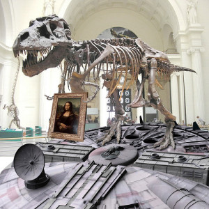
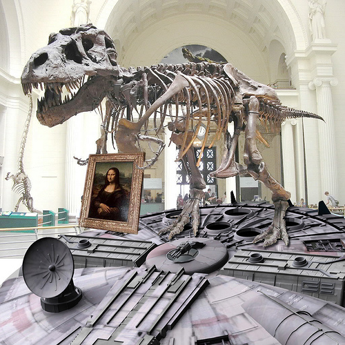
Finally, a silly tweet from me: '#mcn2011 I've decided the perfect visitor-friendly museum is the Mona Lisa on spaceship held by a dinosaur. That you can buy on a t-shirt.' lead to the best thing ever from @timsven: '@mia_out- this pic is for you- museum of the future: trex w/ mona lisa riding millenium falcon #MCN2011 http://t.co/37GdAD1O'.

Museum of the Future

'…and they all turn on their computers and say 'yay!" (aka, 'mapping for humanists')

I'm spending a few hours of my Sunday experimenting with 'mapping for humanists' with an art historian friend, Hannah Williams (@_hannahwill).  We're going to have a go at solving some issues she has encountered when geo-coding addresses in 17th and 18th Century Paris, and we'll post as we go to record the process and hopefully share some useful reflections on what we found as we tried different tools.

We started by working out what issues we wanted to address.  After some discussion we boiled it down to two basic goals: a) to geo-reference historical maps so they can be used to geo-locate addresses and b) to generate maps dynamically from list of addresses. This also means dealing with copyright and licensing issues along the way and thinking about how geospatial tools might fit into the everyday working practices of a historian.  (i.e. while a tool like Google Refine can generate easily generate maps, is it usable for people who are more comfortable with Word than relying on cloud-based services like Google Docs?  And if copyright is a concern, is it as easy to put points on an OpenStreetMap as on a Google Map?)

Like many historians, Hannah's use of maps fell into two main areas: maps as illustrations, and maps as analytic tools.  Maps used for illustrations (e.g. in publications) are ideally copyright-free, or can at least be used as illustrative screenshots.  Interactivity is a lower priority for now as the dataset would be private until the scholarly publication is complete (owing to concerns about the lack of an established etiquette and format for citation and credit for online projects).

Maps used for analysis would ideally support layers of geo-referenced historic maps on top of modern map services, allowing historic addresses to be visually located via contemporaneous maps and geo-located via the link to the modern map.  Hannah has been experimenting with finding location data via old maps of Paris in Hypercities, but manually locating 18th Century streets on historic maps then matching those locations to modern maps is time-consuming and she suspects there are more efficient ways to map old addresses onto modern Paris.

Based on my research interviews with historians and my own experience as a programmer, I'd also like to help humanists generate maps directly from structured data (and ideally to store their data in user-friendly tools so that it's as easy to re-use as it is to create and edit).  I'm not sure if it's possible to do this from existing tools or whether they'd always need an export step, so one of my questions is whether there are easy ways to get records stored in something like Word or Excel into an online tool and create maps from there.  Some other issues historians face in using mapping include: imprecise locations (e.g. street names without house numbers); potential changes in street layouts between historic and modern maps; incomplete datasets; using markers to visually differentiate types of information on maps; and retaining descriptive location data and other contextual information.

Because the challenge is to help the average humanist, I've assumed we should stay away from software that needs to be installed on a server, so to start with we're trying some of the web-based geo-referencing tools listed at http://help.oldmapsonline.org/georeference.

Geo-referencing tools for non-technical people

The first bump in the road was finding maps that are re-usable in technical and licensing terms so that we could link or upload them to the web tools listed at http://help.oldmapsonline.org/georeference.  We've fudged it for now by using a screenshot to try out the tools, but it's not exactly a sustainable solution.  
Hannah's been trying georeferencer.org, Hypercities and Heurist (thanks to Lise Summers ‏@morethangrass on twitter) and has written up her findings at Hacking Historical Maps… or trying to.  Thanks also to Alex Butterworth @AlxButterworth and Joseph Reeves @iknowjoseph for suggestions during the day.

Yahoo! Mapmixer's page was a 404 – I couldn't find any reference to the service being closed, but I also couldn't find a current link for it.

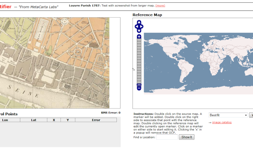
Next I tried Metacarter Labs' Map Rectifier.  Any maps uploaded to this service are publicly visible, though the site says this does 'not grant a copyright license to other users', '[t]here is no expectation of privacy or protection of data', which may be a concern for academics negotiating the line between openness and protecting work-in-progress or anyone dealing with sensitive data.  Many of the historians I've interviewed for my PhD research feel that some sense of control over who can view and use their data is important, though the reasons why and how this is manifested vary.

Screenshot from http://labs.metacarta.com/rectifier/rectify/7192


The site has clear instructions – 'double click on the source map… Double click on the right side to associate that point with the reference map' but the search within the right-hand side 'source map' didn't work and manually navigating to Paris, then the right section of Paris was a huge pain.  Neither of the base maps seemed to have labels, so finding the right location at the right level of zoom was too hard and eventually I gave up.  Maybe the service isn't meant to deal with that level of zoom?  We were using a very small section of map for our trials.

Inspired by Metacarta's Map Rectifier, Map Warper was written with OpenStreetMap in mind, which immediately helps us get closer to the goal of images usable in publications.  Map Warper is also used by the New York Public Library, which described it as a 'tool for digitally aligning ("rectifying") historical maps … to match today's precise maps'.  Map Warper also makes all uploaded maps public: 'By uploading images to the website, you agree that you have permission to do so, and accept that anyone else can potentially view and use them, including changing control points', but also offers 'Map visibility' options 'Public(default)' and 'Don't list the map (only you can see it)'.

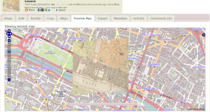
Screenshot showing 'warped' historical map overlaid on OpenStreetMap at http://mapwarper.net/

Once a map is uploaded, it zooms to a 'best guess' location, presumably based on the information you provided when uploading the image.  It's a powerful tool, though I suspect it works better with larger images with more room for error.  Some of the functionality is a little obscure to the casual user – for example, the 'Rectify' view tells me '[t]his map either is not currently masked. Do you want to add or edit a mask now?' without explaining what a mask is.  However, I can live with some roughness around the edges because once you've warped your map (i.e. aligned it with a modern map), there's a handy link on the Export tab, 'View KML in Google Maps' that takes you to your map overlaid on a modern map.  Success!

Sadly not all the export options seem to be complete (they weren't working on my map, anyway) so I couldn't work out if there was a non-geek friendly way to open the map in OpenStreetMap.

We have to stop here for now, but at this point we've met one of the goals – to geo-reference historical maps so locations from the past can be found in the present, but the other will have to wait for another day.  (But I'd probably start with openheatmap.com when we tackle it again.  Any other suggestions would be gratefully received!)

(The title quote is something I heard one non-geek friend say to another to explain what geeks get up to at hackdays. We called our experiment a 'hackday' because we were curious to see whether the format of a hackday – working to meet a challenge within set parameters within a short period of time – would work for other types of projects. While this ended up being almost an 'anti-hack', because I didn't want to write code unless we came across a need for a generic tool, the format worked quite well for getting us to concentrate solidly on a small set of problems for an afternoon.)