Notes from a preview of the updated Historypin

The tl;dr version: inspiring project, great enhancements; yay!

Longer version: last night I went to the offices of We Are What We Do for a preview of the new version of HistoryPin. Nick Poole has already written up his notes, so I'm just supplementing them with my own notes from the event (and a bit from conversations with people there and the reading I'd already done for my PhD).

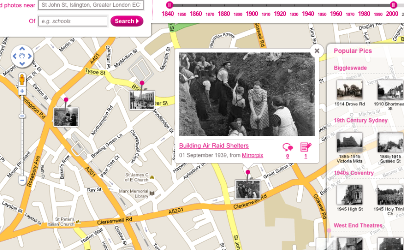
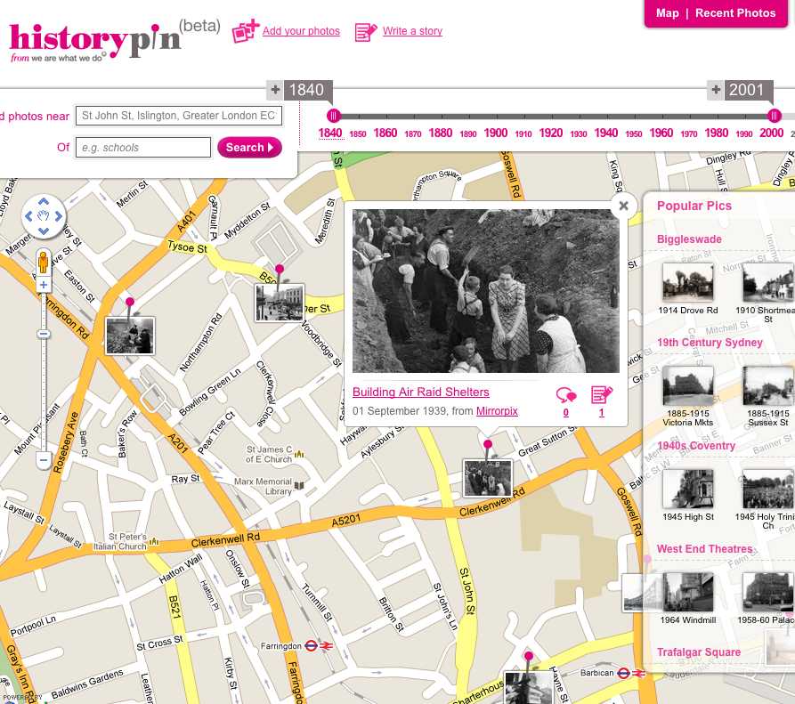
Screenshot with photo near WAWWD office (current site)

Historypin is about bridging the intergenerational divide, about mass participation and access to history, about creating social capital in neighbourhoods, conserving and opening up global archival resources (at this stage that's photographs, not other types of records).  There's a focus on events and activities in local communities. [It'd be great to get kids to do quick oral history interviews as they worked with older people, though I think they're doing something like it already.]

New features will include a lovely augmented reality-style view in streetview; the ability to upload and explore video as well as images; a focus on telling stories – 'tours' let you bring a series of photos together into a narrative (the example was 'the arches of New York', most of which don't exist anymore).  You can also create 'collections', which will be useful for institutions.  They'll also be available in the mobile apps (and yes, I did ask about the possibility of working with the TourML spec for mobile tours).

The mobile apps let you explore your location, explore the map and contribute directly from your phone.  You can use the augmented reality view to overlap old photos onto your camera view so that you can take a modern version of an old photo. This means they can crowdsource better modern images than those available in streetview as well as getting indoors shots.  This could be a great treasure hunt activity for local communities or tourists.  You can also explore collections (as slideshows?) in the app.

They're looking to work with more museums and archives and have been working on a community history project with Reading Museum.  Their focus on inclusion is inspiring, and I'll be interested to see how they work to get those images out into the community.  While there are quite a few 'then and now' projects focused on geo-locating old images around I think that just shows that it's an accessible way of helping people make connections between their lives and those in the past.

A quick correction to Nick's comments – the Historypin API doesn't exist yet, so if you have ideas for what it should do, it's probably a good time to get in touch.  I'll be thinking hard about how it all relates to my PhD, especially if they're making some of the functionality available.

The museum/academic divide, museum labels and mobile-accessible interpretation…

This post from the Smarthistory blog, Writing the Museum Label on a Wiki (and some other ideas), very neatly brings together some of the proposals and conversations from MW2009.

The authors suggest two 'notions' to bring about greater collaboration between museum educators (in the broadest sense) and academics, starting with the premise that:

For some time now, we have been publicly questioning the division that exists between two professional groups tasked with educating the public about art: those in museums (curators and educators) and those in the academy (art historians). These two communities share expertise that is sought by the museum visitor and the student, yet they rarely meet, too often do not attend the same conferences, and almost never collaborate.

I won't pre-empt their notions here – go and read the article, but I just wanted to highlight this quote:

Can the tired modernist fiction that the direct experience of the object must remain unencumbered by the frame of context really still be operative?

I really hope not!

(As an aside, my inner web geek is hugely amused by the irony of the '403' contained within the URL of the article – 403 is the HTTP status code for 'access forbidden'.)

The location-aware future is here (and why cities suck but are good)

Thought-provoking article in Wired on the implications of location-aware devices for our social relationships, privacy concerns, and how we consume and publish geo-located content:

I Am Here: One Man's Experiment With the Location-Aware Lifestyle

The location-aware future—good, bad, and sleazy—is here. Thanks to the iPhone 3G and, to a lesser extent, Google's Android phone, millions of people are now walking around with a gizmo in their pocket that not only knows where they are but also plugs into the Internet to share that info, merge it with online databases, and find out what—and who—is in the immediate vicinity. That old saw about how someday you'll walk past a Starbucks and your phone will receive a digital coupon for half off on a Frappuccino? Yeah, that can happen now.

Simply put, location changes everything. This one input—our coordinates—has the potential to change all the outputs. Where we shop, who we talk to, what we read, what we search for, where we go—they all change once we merge location and the Web.

The article neatly finishes with a sense of 'the more things change, the more things stay the same', which seems to be one of the markers of the moments when technologies are integrated into our lives:

I had gained better location awareness but was losing my sense of place. Sure, with the proper social filters, location awareness needn't be invasive or creepy. But it can be isolating. Even as we gradually digitize our environment, we should remember to look around the old-fashioned way.

Found via Exporting the past into the future, or, "The Possibility Jelly lives on the hypersurface of the present" which in turn came via a tweet.

I also recently enjoyed 'How the city hurts your brain… and what you can do about it'. It's worth learning how you can alleviate the worst symptoms, because it seems cities are worth putting up with:

Recent research by scientists at the Santa Fe Institute used a set of complex mathematical algorithms to demonstrate that the very same urban features that trigger lapses in attention and memory — the crowded streets, the crushing density of people — also correlate with measures of innovation, as strangers interact with one another in unpredictable ways. It is the "concentration of social interactions" that is largely responsible for urban creativity, according to the scientists.

Finding problems for QR tags to solve

QR tags (square or 2D barcodes that can hold up to 4,296 characters) are famously 'big in Japan'. Outside of Japan they've often seemed a solution in search of a problem, but we're getting closer to recognising the situations where they could be useful.

There's a great idea in this blog post, Video Print:

By placing something like a QR code in the margin text at the point you want the reader to watch the video, you can provide an easy way of grabbing the video URL, and let the reader use a device that's likely to be at hand to view the video with…

I would use this a lot myself – my laptop usually lives on my desk, but that's not where I tend to read print media, so in the past I've ripped URLs out of articles or taken a photo on my phone to remind myself to look at them later, but I never get around to it. But since I always have my phone with me I'd happily snap a QR code (the Nokia barcode software is usually hidden a few menus down, but it's worth digging out because it works incredibly well and makes a cool noise when it snaps onto a tag) and use the home wifi connection to view a video or an extended text online.

As a 'call to action' a QR tag may work better than a printed URL because it saves typing in a URL on a mobile keyboard.

QR tags would also work well as physical world hyperlinks, providing a visible sign that information about a particular location is available online or as a short piece of text encoded in the QR tag. They could work as well for a guerrilla campaign to make contested or forgotten histories visible again – stickers are easy to produce and can be replaced if they weather – as for official projects to take cultural heritage content outside the walls of the museum.

The Powerhouse Museum have also experimented with QR tags, creating special offer vouchers.

Here's the obligatory sample QR – if your phone has a barcode reader you should get the URL of this blog*:

qrcode

* which is totally not optimised for mobile reading as the main pages tend to be quite long but it works ok over wifi broadband.

[Update – I just came across this post about Barcode wikipedia that suggests: "People would be able to access the info by entering/scanning the barcode number. The kind of information that would be stored against the product would be things like reviews, manufacturing conditions, news stories about the product/manufacturer, farm subsidies paid to the manufacturer etc." I'm a bit (ok, a lot) of a hippie and check product labels before I buy – I love this idea because it's like a version of the ethical shopping guide small enough to fit inside my wap phone.]

[Update 2 – more discussion of a 'what are QR codes good for' ilk over at http://blog.paulwalk.net/2008/10/24/quite-resourceful/]

"Download costs restrict spread of mobile learning"

Report from the BCS, Download costs restrict spread of mobile learning says:

As mobile devices with internet access become more common, the rise of learning on the move is edging closer. Its uptake is, however, still hampered by the cost to download large volumes of data and the multiplicity of browsers.

Well, yes – but when will that be solved? And how?

Reduced download charges will probably be lead by the music industry, who want us to download ringtones and chart songs.

Interesting use of location-aware devices at the Tower of London.

"The new game employs HP's iPAQ handheld devices and location sensors to trigger the appropriate digital file, which includes voices, images, music and clues.

HP said that developing the new game has helped it to explore opportunities for new products and services that will emerge around the delivery of location and other context-based experiences."

Via the BCS.

I've always wanted to do something like a 'museum outside the walls' where hand-held devices or mobile phones deliver content based on your location. They could be used in walking tours, or signs could let people know that content is available. London has so many layers of history, and the Museum has so much content about London's histories.